
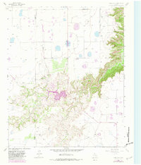
1965 Map of Cope Creek
USGS Topo · Published 1967About this map
Cope Creek carves a deep, winding path through the High Plains landscape of the Texas Panhandle, creating the dramatic topographical relief known as The Narrows. This mid-1960s survey captures the region's ranching character along the boundary of Swisher and Briscoe counties. The map illustrates a landscape of isolated homesteads and working lands, including the Flowers Ranch, Mayfield Ranch, and Martin Ranch, interspersed with infrastructure like a Radio Tower and various Wells.
Find a feature on this map
16 named features on this map. Tap any name to fly to it.
Don’t see what you’re looking for? This feature index may not catch every label — zoom into the map to look around manually.
Map Details
Editions of this 1965 Cope Creek Map
2 editions found
Other maps of this area

1954 · Plainview
USGS Topo · 1:250,000

1958 · Plainview
USGS Topo · 1:250,000

1965 · Ross Canyon
USGS Topo · 1:24,000

1965 · Big Betty Reservoir
USGS Topo · 1:24,000

1965 · Silverton
USGS Topo · 1:24,000

1965 · Rock Creek
USGS Topo · 1:24,000

1965 · Vigo Park
USGS Topo · 1:24,000

1969 · Love
USGS Topo · 1:24,000

1969 · Jackson Hill
USGS Topo · 1:24,000

1969 · Claytonville
USGS Topo · 1:24,000