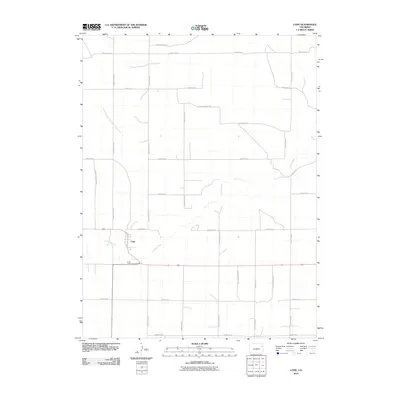
2010 Map of Cope
USGS Topo · Published 2010About this map
Cope sits as a primary settlement node in this High Plains landscape, situated along the meandering course of the Arikaree River. The 2010 geography is defined by a rigid section-line grid of rural routes, including County Road XX, County Road YY, and County Road ZZ, which facilitate movement across the agricultural expanses of Washington County. This network of unpaved and improved roads connects isolated farmsteads to the central community and the Cope Community Cemetery located just south of the main town site. The river itself creates a distinct diagonal break in the otherwise orthogonal landscape, its riparian corridor providing a natural contrast to the surveyed precision of the surrounding plains. The prominence of long-distance county connectors like County Road C and County Road AAA illustrates the spatial organization of this eastern Colorado region, where distance and utility dictate the placement of infrastructure.
Find a feature on this map
22 named features on this map. Tap any name to fly to it.
Don’t see what you’re looking for? This feature index may not catch every label — zoom into the map to look around manually.
Map Details
Editions of this 2010 Cope Map
This is the sole edition of this map. No revisions or reprints were ever made.
Other maps of this area
1954 · Limon
USGS Topo · 1:250,000
1957 · Limon
USGS Topo · 1:250,000
1958 · Limon
USGS Topo · 1:250,000
1968 · Joes
USGS Topo · 1:24,000
1974 · De Nova SE
USGS Topo · 1:24,000
1974 · Abarr
USGS Topo · 1:24,000
1977 · Cope
USGS Topo · 1:24,000
1977 · Cope SE
USGS Topo · 1:24,000
1977 · Cope SW
USGS Topo · 1:24,000
1978 · Cope NW
USGS Topo · 1:24,000