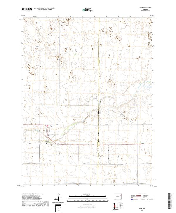
2022 Map of Cope
USGS Topo · Published 2022About this map
Cope sits as a primary point of interest in this eastern Colorado landscape, serving as a hub for the surrounding agricultural plains. The settlement is anchored by local infrastructure including the Po and a grid defined by Main St and 3rd St. Just to the south, the Cope Community Cem provides a focal point for genealogical research and local heritage. The terrain is defined by the winding course of the Arikaree River, which cuts across the high plains, influencing the local topography and the placement of section roads. The map captures a transition between Washington Co and Yuma Co, illustrating a rural network of county roads such as Co Rd 6 and Co Rd XX that facilitate movement across the vast township and range system.
Find a feature on this map
26 named features on this map. Tap any name to fly to it.
Don’t see what you’re looking for? This feature index may not catch every label — zoom into the map to look around manually.
Map Details
Editions of this 2022 Cope Map
This is the sole edition of this map. No revisions or reprints were ever made.
Other maps of this area

1954 · Limon
USGS Topo · 1:250,000

1957 · Limon
USGS Topo · 1:250,000

1958 · Limon
USGS Topo · 1:250,000

1968 · Joes
USGS Topo · 1:24,000

1974 · De Nova SE
USGS Topo · 1:24,000
1974 · Abarr
USGS Topo · 1:24,000

1977 · Cope
USGS Topo · 1:24,000

1977 · Cope SE
USGS Topo · 1:24,000

1977 · Cope SW
USGS Topo · 1:24,000
1978 · Cope NW
USGS Topo · 1:24,000