
1970 Map of Copeland
USGS Topo · Published 1973About this map
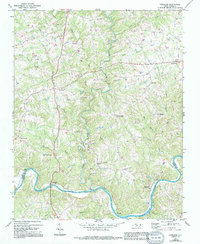
The Fisher River meanders south through the rural landscape of Surry County, meeting the Yadkin River at the southern boundary of this 1970s era survey. This riverine landscape is defined by its small crossroads settlements and numerous community centers, such as Copeland, Rockford, and Crutchfield. The area's social fabric is clearly visible through a high density of rural churches, including New Hope Ch, Liberty Ch, and Mount Herman Ch, often situated on the ridges between watercourses like Cody Creek and Bear Creek. The Southern railroad line follows the northern bank of the Yadkin River, serving the small riverside communities and linking this agricultural region to the broader rail economy. Topographic details reveal a terrain of frequent elevation changes, notably around Pheasant and Stony Knoll, where small cemeteries and family-named land features provide essential data for local historians and genealogists.
Find a feature on this map
33 named features on this map. Tap any name to fly to it.
Don’t see what you’re looking for? This feature index may not catch every label — zoom into the map to look around manually.
Map Details
Editions of this 1970 Copeland Map
2 editions found
Other maps of this area

1891 · Yadkinville
USGS Topo · 1:125,000

1893 · Yadkinville
USGS Topo · 1:125,000

1953 · Winston-Salem
USGS Topo · 1:250,000

1955 · Winston-Salem
USGS Topo · 1:250,000

1962 · Winston-Salem
USGS Topo · 1:250,000

1966 · Yadkinville
USGS Topo · 1:24,000

1966 · East Bend
USGS Topo · 1:24,000
1970 · Siloam
USGS Topo · 1:24,000
1970 · Mount Airy South
USGS Topo · 1:24,000
1971 · Dobson
USGS Topo · 1:24,000