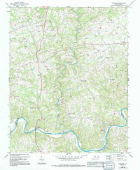
1970 Map of Copeland
USGS Topo · Published 1994About this map
The Yadkin River defines the southern boundary of this Piedmont landscape, marking the border where Surry Co meets Yadkin County. Small rural communities like Rockford and Crutchfield are situated along the river's path, while the interior is dotted with historic congregational landmarks such as Mount Herman Ch and Mt Pleasant Ch. The map illustrates a transitional period of development, with 1990s-era revisions in purple highlighting the growth of residential structures and farm buildings around established settlements like Copeland and Stony Knoll.
Find a feature on this map
28 named features on this map. Tap any name to fly to it.
Don’t see what you’re looking for? This feature index may not catch every label — zoom into the map to look around manually.
Map Details
Editions of this 1970 Copeland Map
2 editions found
Other maps of this area

1891 · Yadkinville
USGS Topo · 1:125,000

1893 · Yadkinville
USGS Topo · 1:125,000

1953 · Winston-Salem
USGS Topo · 1:250,000

1955 · Winston-Salem
USGS Topo · 1:250,000

1962 · Winston-Salem
USGS Topo · 1:250,000

1966 · Yadkinville
USGS Topo · 1:24,000

1966 · East Bend
USGS Topo · 1:24,000
1970 · Siloam
USGS Topo · 1:24,000

1970 · Copeland
USGS Topo · 1:24,000
1970 · Mount Airy South
USGS Topo · 1:24,000