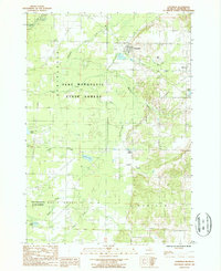
1987 Map of Copemish
USGS Topo · Published 1988About this map
The Copemish village site anchors this landscape in Manistee County, situated at the intersection of several significant townships including Springdale, Cleon, Maple Grove, and Marilla. Much of the terrain is defined by the Pere Marquette State Forest, which covers extensive sections of the quadrangle. The hydrology of the area is particularly detailed, featuring a series of numbered tributaries—First Creek, Second Creek, and Third Creek—that feed into larger systems like Bear Creek and Dutchman Creek.
Find a feature on this map
31 named features on this map. Tap any name to fly to it.
Don’t see what you’re looking for? This feature index may not catch every label — zoom into the map to look around manually.
Map Details
Editions of this 1987 Copemish Map
This is the sole edition of this map. No revisions or reprints were ever made.
Other maps of this area

1954 · Traverse City
USGS Topo · 1:250,000

1954 · Manitowoc
USGS Topo · 1:250,000

1956 · Onekama
USGS Topo · 1:62,500

1956 · Thompsonville
USGS Topo · 1:62,500

1956 · Frankfort
USGS Topo · 1:62,500

1957 · Copemish
USGS Topo · 1:62,500

1958 · Traverse City
USGS Topo · 1:250,000

1958 · Manitowoc
USGS Topo · 1:250,000

1976 · Frankfort SE
USGS Topo · 1:24,000

1976 · Onekama SE
USGS Topo · 1:24,000
Featured Places
- Copemish, Cleon Township
- Cleon Township, MI
- Maple Grove Township, MI
- Marilla Township, MI
- Springdale Township, MI