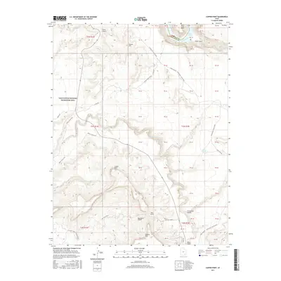
2017 Map of Copper Point
USGS Topo · Published 2017About this map
Copper Point stands as a prominent landmark in this desert landscape of Glen Canyon National Recreation Area, where the drainage of White Canyon Cr cuts through the high plateaus. The topography is defined by massive formations such as Browns Rim, Wingate Mesa, and Dry Mesa, which create a complex network of canyons and mesas. In the northeast, the Colorado River winds through Mille Crag Bend before opening into the waters of Lake Powell. This 2017 survey details the access routes through the back country, including the rugged Fortknocker Canyon Road, White Canyon N Road, and the historical White Canyon Trail. The map documents a landscape where traditional overland routes meet the modern shoreline of the reservoir, capturing the geographic transition between the high desert of Blue Notch and the deep river corridors of Sheep Canyon and Farley Canyon.
Find a feature on this map
26 named features on this map. Tap any name to fly to it.
Don’t see what you’re looking for? This feature index may not catch every label — zoom into the map to look around manually.
Map Details
Editions of this 2017 Copper Point Map
This is the sole edition of this map. No revisions or reprints were ever made.
Other maps of this area

1886 · Henry Mountains
USGS Topo · 1:250,000

1892 · Henry Mountains
USGS Topo · 1:250,000

1952 · Mouth of Dark Canyon
USGS Topo · 1:62,500

1952 · Mancos Mesa
USGS Topo · 1:62,500

1952 · Natural Bridges
USGS Topo · 1:62,500

1952 · Hite
USGS Topo · 1:62,500
1954 · White Canyon 2 NE
USGS Topo · 1:24,000

1954 · White Canyon 3 NW
USGS Topo · 1:24,000

1954 · White Canyon 3 NE
USGS Topo · 1:24,000
1954 · White Canyon 2 SW
USGS Topo · 1:24,000