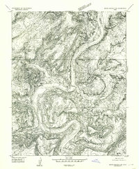
1954 Map of White Canyon 2 SW
USGS Topo · Published 1954About this map
Hite serves as a focal point in this remote corner of southeastern Utah, situated at a strategic crossing point where the Colorado River winds through the deep incisions of Glen Canyon. This 1952 survey, published just years before the landscape was fundamentally altered by downstream damming, documents a river-based infrastructure that includes a ferry and a Gaging Sta near the mouth of White Canyon. The map reveals the early transport network of the region, featuring multiple Landing Fields and unimproved roads that navigate the complex drainage systems of Trachyte Creek and Fourmile Canyon. The dramatic topography is highlighted by The Horn, a massive river bend that illustrates the power of the water's path through the high desert plateau. This preliminary edition provides a precise view of the canyon floor and riverside settlements as they existed in the mid-20th century.
Find a feature on this map
15 named features on this map. Tap any name to fly to it.
Don’t see what you’re looking for? This feature index may not catch every label — zoom into the map to look around manually.
Map Details
Editions of this 1954 White Canyon 2 SW Map
This is the sole edition of this map. No revisions or reprints were ever made.
Other maps of this area

1886 · Henry Mountains
USGS Topo · 1:250,000

1892 · Henry Mountains
USGS Topo · 1:250,000

1952 · Mancos Mesa
USGS Topo · 1:62,500

1952 · Mt Pennell 1 NE
USGS Topo · 1:24,000

1952 · Mt Hillers
USGS Topo · 1:62,500

1952 · Mt Pennell 1 SE
USGS Topo · 1:24,000

1952 · Hite
USGS Topo · 1:62,500

1953 · Mt Pennell 4 NE
USGS Topo · 1:24,000

1953 · Mt. Ellsworth
USGS Topo · 1:62,500
1954 · White Canyon 2 NE
USGS Topo · 1:24,000