
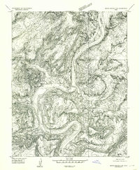
1953 Map of Mt Pennell 4 NE
USGS Topo · Published 1954About this map
The Colorado River carves a dramatic path through this high desert terrain, marking the winding border where Garfield and San Juan counties meet. The landscape is dominated by the sprawling plateau of Ticaboo Mesa, which rises above a complex network of canyons and drainage systems. This 1953 survey, based on aerial photography from 1951, captures the area's geography before significant human development or major hydrological changes downstream. Notable geological formations are clearly delineated, including the sharp bend of The Rincon and the area near Good Hope. The map's high-relief contour lines provide a precise record of the verticality and erosion patterns that define this stretch of the river corridor during the early 1950s.
Find a feature on this map
5 named features on this map. Tap any name to fly to it.
Don’t see what you’re looking for? This feature index may not catch every label — zoom into the map to look around manually.
Map Details
Editions of this 1953 Mt Pennell 4 NE Map
This is the sole edition of this map. No revisions or reprints were ever made.
Other maps of this area

1886 · Henry Mountains
USGS Topo · 1:250,000

1892 · Henry Mountains
USGS Topo · 1:250,000

1952 · Mt Pennell 1 SW
USGS Topo · 1:24,000

1952 · Mancos Mesa
USGS Topo · 1:62,500

1952 · Mt Hillers
USGS Topo · 1:62,500

1952 · Mt Pennell 1 SE
USGS Topo · 1:24,000

1952 · Hite
USGS Topo · 1:62,500

1953 · Mt. Ellsworth
USGS Topo · 1:62,500

1954 · White Canyon 3 NW
USGS Topo · 1:24,000
1954 · White Canyon 2 SW
USGS Topo · 1:24,000