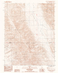
1984 Map of Copper Queen Canyon
USGS Topo · Published 1984About this map
The Slate Range dominates this mid-1980s topographic survey, providing a sharp contrast to the low-lying Panamint Valley to the east. This transition from high peaks to valley floor is punctuated by several mining sites, reflecting the region's long-standing connection to mineral extraction. Notable sites include the January Jones Mine, the Standard Mine, and the Crescent Mines located further north. Much of the southern landscape falls within the U S Naval Reservation, where the Naval Reservation Boundary cuts across the mountains at the border of Inyo and San Bernardino counties. A network of steep drainages, including Copper Queen Canyon and Bundy Canyon, carve through the range toward the valley floor. Transportation is limited in this arid environment, with Wingate Road and various unimproved trails providing the primary access to the scattered mines and the seasonal Dry Lake near the northern boundary.
Find a feature on this map
15 named features on this map. Tap any name to fly to it.
Don’t see what you’re looking for? This feature index may not catch every label — zoom into the map to look around manually.
Map Details
Editions of this 1984 Copper Queen Canyon Map
This is the sole edition of this map. No revisions or reprints were ever made.
Other maps of this area

1915 · Searles Lake
USGS Topo · 1:250,000

1947 · Trona
USGS Topo · 1:250,000

1948 · Trona
USGS Topo · 1:250,000

1949 · Trona
USGS Topo · 1:62,500

1949 · Searles Lake
USGS Topo · 1:62,500

1950 · Searles Lake
USGS Topo · 1:62,500

1950 · Trona
USGS Topo · 1:62,500

1950 · Manly Peak
USGS Topo · 1:62,500

1950 · Wingate Pass
USGS Topo · 1:62,500

1951 · Wingate Pass
USGS Topo · 1:62,500