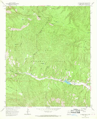
1965 Map of Copperas Peak
USGS Topo · Published 1969About this map
Lake Roberts serves as a central recreational landmark in this mid-century survey of the Gila high country, surrounded by the Mesa Campground, Lake Roberts Campground, and Upper End Campground. The landscape is defined by the drainage of Sapillo Creek and the rugged heights of Copperas Peak and Buck Hannen Mountain. Evidence of early 20th-century industry persists at the Meerschaum Mine, situated near Salt Creek. This mineral, once prized for tobacco pipes, is a rare find in the United States, giving this specific corner of the Gila National Forest a unique geological and industrial profile. Transportation across the drainage is marked by The Military Road and the Sapillo Trail, while numerous livestock tanks like Corral Tank and Meerschaum Tank indicate the ongoing use of the Gila Wilderness and surrounding forest for ranching.
Find a feature on this map
33 named features on this map. Tap any name to fly to it.
Don’t see what you’re looking for? This feature index may not catch every label — zoom into the map to look around manually.
Map Details
Editions of this 1965 Copperas Peak Map
2 editions found
Other maps of this area

1909 · Silver City
USGS Topo · 1:125,000

1911 · Alum Mountain
USGS Topo · 1:125,000

1913 · Alum Mountain
USGS Topo · 1:125,000

1947 · Allie Canyon
USGS Topo · 1:24,000

1947 · Twin Sisters
USGS Topo · 1:24,000

1948 · Twin Sisters
USGS Topo · 1:24,000

1948 · Allie Canyon
USGS Topo · 1:24,000

1950 · Reading Mountain
USGS Topo · 1:24,000
1952 · Reading Mountain
USGS Topo · 1:24,000

1954 · Silver City
USGS Topo · 1:250,000