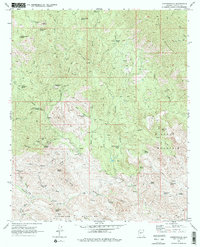
1969 Map of Copperopolis
USGS Topo · Published 1977About this map
The Copperopolis (Site) and its namesake Copperopolis Mine anchor this high-elevation mining landscape in late-1960s Arizona. The area is defined by a deep history of extraction, evidenced by the Lehman Mill and scattered workings like the McKinley Mine and Whipsaw Mine. Topography is dominated by prominent peaks including Castle Rock, Silver Mountain, and Black Butte, which rise above a network of seasonal drainages such as Copperopolis Creek and Walker Gulch.
Find a feature on this map
56 named features on this map. Tap any name to fly to it.
Don’t see what you’re looking for? This feature index may not catch every label — zoom into the map to look around manually.
Map Details
Editions of this 1969 Copperopolis Map
3 editions found
Other maps of this area

1887 · Prescott
USGS Topo · 1:250,000

1892 · Prescott
USGS Topo · 1:250,000

1903 · Bradshaw Mountains
USGS Topo · 1:125,000

1903 · Congress
USGS Topo · 1:125,000

1904 · Congress
USGS Topo · 1:125,000

1947 · Crown King
USGS Topo · 1:62,500

1947 · Wagoner
USGS Topo · 1:62,500

1948 · Crown King
USGS Topo · 1:63,360

1948 · Wagoner
USGS Topo · 1:63,360

1950 · Wagoner
USGS Topo · 1:62,500