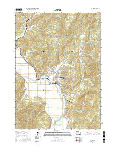
2017 Map of Coquille
USGS Topo · Published 2017About this map
The Coquille River winds through the heart of the Coquille Valley, anchoring a landscape defined by its timber heritage and river-bottom agriculture. In the city of Coquille, the street grid extends toward the Dutch John Ravine, while local history is preserved at the Independent Order of Old Fellows Cem and Masonic Cem. To the north, the settlement of Coaledo sits near Beaver Slough, a reminder of the region's historical coal and rail connections.
Find a feature on this map
86 named features on this map. Tap any name to fly to it.
Don’t see what you’re looking for? This feature index may not catch every label — zoom into the map to look around manually.
Map Details
Editions of this 2017 Coquille Map
This is the sole edition of this map. No revisions or reprints were ever made.
Other maps of this area

1896 · Coos Bay
USGS Topo · 1:125,000

1898 · Coos Bay
USGS Topo · 1:125,000

1900 · Coos Bay
USGS Topo · 1:125,000

1942 · Empire
USGS Topo · 1:62,500

1942 · Coquille
USGS Topo · 1:62,500

1942 · Coos Bay
USGS Topo · 1:62,500

1943 · Bandon
USGS Topo · 1:62,500

1944 · Empire
USGS Topo · 1:62,500

1944 · Bandon
USGS Topo · 1:62,500

1945 · Coquille
USGS Topo · 1:62,500