
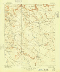
1892 Map of Corazon
USGS Topo · Published 1892About this map
San Miguel county land at the end of the nineteenth century is defined by its dramatic mesa topographies and the essential network of springs and streams that supported local ranching and settlement. Topographers J.B. Lippincott and Jos. Jacobs mapped this high-desert territory, recording the small villages and plazas that clustered near water sources. Significant settlements like Chaperito, Aguila, and La Cueva are situated along the lower valleys, while the interior is marked by prominent natural landmarks such as Carro Mesa, Mesa Montosa, and Yegu Mesa. The map illustrates a reliance on reliable water points in a demanding landscape, specifically noting several vital desert sources including Gallinas Spring, Concha Spring, and Cabra Spring. These landmarks and the Conchas River drainage system provided the necessary infrastructure for the early communities that dotted the canyons and plains of central New Mexico during this era.
Find a feature on this map
39 named features on this map. Tap any name to fly to it.
Don’t see what you’re looking for? This feature index may not catch every label — zoom into the map to look around manually.
Map Details
Editions of this 1892 Corazon Map
2 editions found
Other maps of this area

1889 · Las Vegas
USGS Topo · 1:125,000

1890 · Bernal
USGS Topo · 1:125,000

1891 · Bernal
USGS Topo · 1:125,000

1891 · Las Vegas
USGS Topo · 1:125,000

1892 · Watrous
USGS Topo · 1:125,000

1893 · Las Vegas
USGS Topo · 1:125,000

1894 · Corazon
USGS Topo · 1:125,000

1894 · Watrous
USGS Topo · 1:125,000

1894 · Bernal
USGS Topo · 1:125,000

1954 · Santa Fe
USGS Topo · 1:250,000