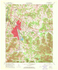
1970 Map of Corbin
USGS Topo · Published 1972About this map
The city of Corbin serves as a major regional hub at the junction of Laurel, Knox, and Whitley counties in the early 1970s. This industrial and transportation center is defined by the Louisville and Nashville Railroad, which cuts through the heart of the settlement alongside the Industrial Waste Ponds. The map reveals a densely developed community with numerous educational and religious institutions, including St Camillus Academy, South Ward Sch, and Central Sch.
Find a feature on this map
53 named features on this map. Tap any name to fly to it.
Don’t see what you’re looking for? This feature index may not catch every label — zoom into the map to look around manually.
Map Details
Editions of this 1970 Corbin Map
3 editions found
Other maps of this area

1886 · Cumberland Gap
USGS Topo · 1:125,000

1888 · Cumberland Gap
USGS Topo · 1:125,000

1890 · Williamsburg
USGS Topo · 1:125,000

1891 · Manchester
USGS Topo · 1:125,000

1891 · Cumberland Gap
USGS Topo · 1:125,000

1893 · London
USGS Topo · 1:125,000

1894 · Williamsburg
USGS Topo · 1:125,000

1897 · London
USGS Topo · 1:125,000

1952 · Corbin
USGS Topo · 1:24,000

1952 · Wofford
USGS Topo · 1:24,000