
1956 Map of Cordell
USGS Topo · Published 1958About this map
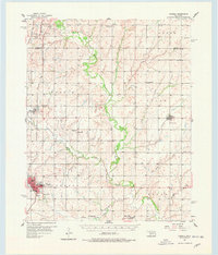
Cordell serves as the regional hub of Washita County in the mid-1950s, its street grid and community infrastructure including the High Sch and Cordell Airport clearly defined. The St Louis - San Francisco railroad provides the primary industrial artery, connecting Bessie to the larger market centers. The rural landscape is densely marked by the spiritual and social foundations of early Oklahoma settlement, evidenced by numerous country churches such as Bergthal Ch, Bessie Ch, and the Union Ch. Local history researchers will find a high concentration of burial sites, including the Old Crow Cem and Sichar Cem, which often represent the only remaining physical traces of vanished community clusters. The meandering course of the Washita River and its tributaries like Cavalry Creek dictate the topography of the agricultural sections, where even an Abandoned Chapel Hill Sch remains noted on the landscape.
Find a feature on this map
44 named features on this map. Tap any name to fly to it.
Don’t see what you’re looking for? This feature index may not catch every label — zoom into the map to look around manually.
Map Details
Editions of this 1956 Cordell Map
2 editions found
Other maps of this area

1955 · Clinton
USGS Topo · 1:250,000

1957 · Clinton
USGS Topo · 1:250,000

1957 · Butler
USGS Topo · 1:62,500

1957 · Clinton
USGS Topo · 1:62,500

1957 · Dill City
USGS Topo · 1:62,500

1961 · Gotebo
USGS Topo · 1:62,500

1961 · Eakly
USGS Topo · 1:62,500

1961 · Hobart
USGS Topo · 1:62,500

1961 · Carnegie
USGS Topo · 1:62,500

1964 · Weatherford
USGS Topo · 1:62,500