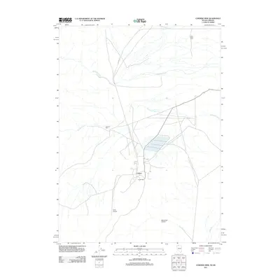
2011 Map of Cordero Mine
USGS Topo · Published 2011About this map
Cordero Mine anchors this high-desert landscape on the border of Nevada and Oregon, representing a significant industrial presence in the arid basin. The small settlement of Cordero sits near the mining operations, while large agricultural holdings like Lucky Seven Ranch and Washburn Ranch indicate the dual economic drivers of resource extraction and ranching. The terrain is defined by drainages such as McDermitt Creek and Washburn Creek that flow toward the Quinn River in the southeast corner. Transportation through the area is facilitated by CO Line RD, which traces the geographic boundary between states. The transition from the open flats to the steeper elevations of Long Canyon and McConnell Canyon highlights the typical Great Basin topography where remote ranching outposts and mineral deposits dictate the pattern of human settlement.
Find a feature on this map
10 named features on this map. Tap any name to fly to it.
Don’t see what you’re looking for? This feature index may not catch every label — zoom into the map to look around manually.
Map Details
Editions of this 2011 Cordero Mine Map
This is the sole edition of this map. No revisions or reprints were ever made.
Other maps of this area

1882 · Paradise
USGS Topo · 1:250,000

1893 · Paradise
USGS Topo · 1:250,000

1955 · McDermitt
USGS Topo · 1:250,000

1955 · Jordan Valley
USGS Topo · 1:250,000

1957 · Jordan Valley
USGS Topo · 1:250,000

1958 · Jordan Valley
USGS Topo · 1:250,000

1959 · McDermitt
USGS Topo · 1:250,000

1959 · McDermitt
USGS Topo · 1:62,500

1959 · Jordan Meadow
USGS Topo · 1:62,500
1982 · Tenmile Ranch
USGS Topo · 1:24,000