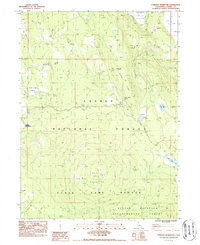
1983 Map of Corders Reservoir
USGS Topo · Published 1987About this map
Blacks Mountain Experimental Forest and the surrounding Lassen National Forest dominate this landscape in northeastern California as it appeared in the early 1980s. The map documents a rugged terrain shaped by forestry research and seasonal water management, featuring numerous catchments like Corders Reservoir and Railroad Reservoir. Evidence of historic human presence is found at the Eldridge Homestead (Site) and along the Lassen Trail, a primary emigrant route. The mapping of the Old Railroad Grade and numerous Borrow Pits highlights the area's industrial footprint and timber-hauling history. High points such as Blacks Mountain are complemented by detailed markers for mountain infrastructure, including a Lookout Tower and Blacks Cabin Flat, while a network of named springs like Gibbs Spring and Blacks Ridge Spring indicate the critical importance of water sources in this high-elevation forest and game refuge environment.
Find a feature on this map
28 named features on this map. Tap any name to fly to it.
Don’t see what you’re looking for? This feature index may not catch every label — zoom into the map to look around manually.
Map Details
Editions of this 1983 Corders Reservoir Map
2 editions found
Other maps of this area

1886 · Lassen Peak
USGS Topo · 1:250,000

1892 · Lassen Peak
USGS Topo · 1:250,000

1894 · Lassen Peak
USGS Topo · 1:250,000

1939 · Halls Flat
USGS Topo · 1:125,000

1955 · Westwood
USGS Topo · 1:250,000

1956 · Harvey Mtn
USGS Topo · 1:62,500

1957 · Prospect Peak
USGS Topo · 1:62,500

1957 · Little Valley
USGS Topo · 1:62,500

1957 · Jellico
USGS Topo · 1:62,500

1958 · Westwood
USGS Topo · 1:250,000