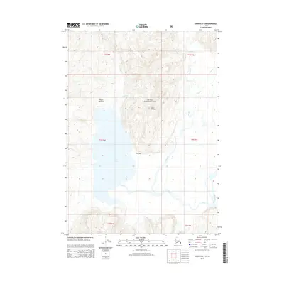
2014 Map of Cordova B-1 SW
USGS Topo · Published 2014About this map
Bering Lake and the Bering River dominate this coastal Alaskan landscape, where the glacial drainage systems meet the tidal influence of the Gulf of Alaska. The terrain is defined by the steep southern reaches of the Chugach Mountains, rising sharply from the basin to the summit of Mount Hamilton. This 2014 survey documents a complex hydrological network within the Chugach National Forest, featuring numerous named waterways such as Shepherd Cr, Steele Cr, and Dick Cr that carve through the high-elevation contours. At the northern edge of the lake, Poul Point stands as a distinct topographical marker where the mountains meet the water. The map provides a clear record of the area's natural boundaries and the intricate paths of creeks like Falls Eagle and Basin Cr as they flow toward the coastal flats.
Find a feature on this map
20 named features on this map. Tap any name to fly to it.
Don’t see what you’re looking for? This feature index may not catch every label — zoom into the map to look around manually.
Map Details
Editions of this 2014 Cordova B-1 SW Map
This is the sole edition of this map. No revisions or reprints were ever made.
Other maps of this area

1948 · Cordova
USGS Topo · 1:250,000

1950 · Cordova B-2
USGS Topo · 1:63,360

1950 · Cordova A-1
USGS Topo · 1:63,360

1950 · Cordova A-2
USGS Topo · 1:63,360

1951 · Cordova
USGS Topo · 1:250,000

1951 · Cordova B-1
USGS Topo · 1:63,360

1953 · Cordova A-2
USGS Topo · 1:63,360

1953 · Cordova B-1
USGS Topo · 1:63,360

1953 · Cordova B-2
USGS Topo · 1:63,360
1953 · Cordova A-1
USGS Topo · 1:63,360