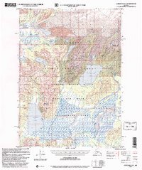
1997 Map of Cordova B-1
USGS Topo · Published 2000About this map
Martin River Glacier dominates the northern reaches of this coastal wilderness, where ice and silt define the shifting landscape. The terrain transitions south into the high peaks of the Chugach Mountains, including Monument Mountain and the Kushtaka Ridge. Traces of early 20th-century exploration and industry are visible at Carbon Camp (Ruins) and various other Cabin (Ruins) sites near Carbon Creek, reflecting a period when coal and minerals drew prospectors into the Copper River Delta.
Find a feature on this map
42 named features on this map. Tap any name to fly to it.
Don’t see what you’re looking for? This feature index may not catch every label — zoom into the map to look around manually.
Map Details
Editions of this 1997 Cordova B-1 Map
This is the sole edition of this map. No revisions or reprints were ever made.
Other maps of this area

1948 · Cordova
USGS Topo · 1:250,000

1950 · Bering Glacier
USGS Topo · 1:250,000

1950 · Cordova B-2
USGS Topo · 1:63,360

1950 · Cordova A-1
USGS Topo · 1:63,360

1950 · Cordova A-2
USGS Topo · 1:63,360

1951 · Bering Glacier
USGS Topo · 1:250,000

1951 · Cordova
USGS Topo · 1:250,000

1951 · Cordova B-1
USGS Topo · 1:63,360

1953 · Cordova A-2
USGS Topo · 1:63,360

1953 · Cordova B-1
USGS Topo · 1:63,360