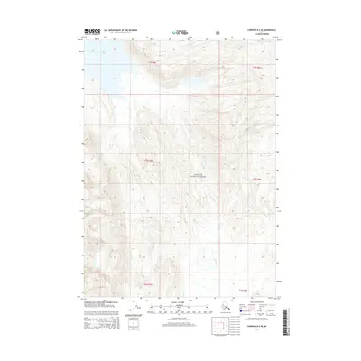
2014 Map of Cordova B-2 SE
USGS Topo · Published 2014About this map
Chugach National Forest land defines this portion of the Gulf of Alaska coastline, where the landscape is shaped by the descent of coastal mountains toward the sea. The northern edge of the map is dominated by Martin Lake, a significant water body situated at the base of steep elevation contours. Flowing southward through the central terrain, the Katalla River creates a primary drainage corridor, eventually joined by Clear Cr as the topography levels out toward the coast. This 2014 survey documents a wilderness area defined by its hydrology and federal forest boundaries, showing the complex drainage patterns and relief typical of the region before it meets the Pacific. The lack of roads or established settlements emphasizes the remote nature of this coastal forest environment.
Find a feature on this map
10 named features on this map. Tap any name to fly to it.
Don’t see what you’re looking for? This feature index may not catch every label — zoom into the map to look around manually.
Map Details
Editions of this 2014 Cordova B-2 SE Map
This is the sole edition of this map. No revisions or reprints were ever made.
Other maps of this area

1948 · Cordova
USGS Topo · 1:250,000

1950 · Cordova B-2
USGS Topo · 1:63,360

1950 · Cordova A-1
USGS Topo · 1:63,360

1950 · Cordova A-2
USGS Topo · 1:63,360

1951 · Cordova
USGS Topo · 1:250,000

1951 · Cordova B-1
USGS Topo · 1:63,360

1953 · Cordova A-2
USGS Topo · 1:63,360

1953 · Cordova B-1
USGS Topo · 1:63,360

1953 · Cordova B-2
USGS Topo · 1:63,360
1953 · Cordova A-1
USGS Topo · 1:63,360