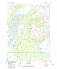
1983 Map of Cordova C-4 SW
USGS Topo · Published 1983About this map
The Scott Glacier and Sheridan Glacier dominate the landscape of this portion of the Chugach National Forest in the early 1980s. The region is characterized by an intricate drainage system where the Scott River and Ibeck Creek flow through outwash plains and glacial valleys. Near the center of the sheet, a cluster of small water bodies including Siamese Lakes, Lake Elsner, and Beaver Lake provides evidence of the area's complex post-glacial hydrology. Recreational infrastructure is concentrated near the lower left, where the Cabin Lake Campground and a Picnic Area sit adjacent to Cabin Lake and Meeks Pond. A dedicated Pack Trail and a Foot Bridge suggest the methods of inland navigation used by forest visitors and surveyors during this era, while the southern margin touches the Airport Boundary.
Find a feature on this map
23 named features on this map. Tap any name to fly to it.
Don’t see what you’re looking for? This feature index may not catch every label — zoom into the map to look around manually.
Map Details
Editions of this 1983 Cordova C-4 SW Map
This is the sole edition of this map. No revisions or reprints were ever made.
Other maps of this area

1948 · Cordova
USGS Topo · 1:250,000

1950 · Cordova C-4
USGS Topo · 1:63,360

1951 · Cordova
USGS Topo · 1:250,000

1951 · Cordova B-4
USGS Topo · 1:63,360

1951 · Cordova C-5
USGS Topo · 1:63,360

1951 · Cordova B-5
USGS Topo · 1:63,360

1953 · Cordova B-5
USGS Topo · 1:63,360

1953 · Cordova C-4
USGS Topo · 1:63,360

1953 · Cordova C-5
USGS Topo · 1:63,360

1959 · Cordova
USGS Topo · 1:250,000