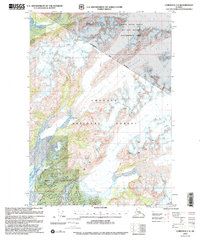
2000 Map of Cordova C-4
USGS Topo · Published 2002About this map
The Chugach National Forest terrain dominates this survey, where massive ice fields and braided river systems define the landscape. The northeastern portion of the map is dedicated to the Copper River Delta Fish and Wildlife Management Area, a critical habitat where the Rude River and Sheridan River transport glacial melt toward the coast. Large ice bodies including Scott Glacier, Sherman Glacier, Shephard Glacier, and Sheridan Glacier are mapped in detail, showing their extensive flow patterns across the mountains.
Find a feature on this map
25 named features on this map. Tap any name to fly to it.
Don’t see what you’re looking for? This feature index may not catch every label — zoom into the map to look around manually.
Map Details
Editions of this 2000 Cordova C-4 Map
This is the sole edition of this map. No revisions or reprints were ever made.
Other maps of this area

1948 · Cordova
USGS Topo · 1:250,000

1950 · Cordova C-4
USGS Topo · 1:63,360

1950 · Cordova D-3
USGS Topo · 1:63,360

1950 · Cordova D-5
USGS Topo · 1:63,360

1951 · Cordova
USGS Topo · 1:250,000

1951 · Cordova B-4
USGS Topo · 1:63,360

1951 · Cordova C-5
USGS Topo · 1:63,360

1951 · Cordova B-5
USGS Topo · 1:63,360

1951 · Cordova C-3
USGS Topo · 1:63,360

1951 · Cordova D-4
USGS Topo · 1:63,360