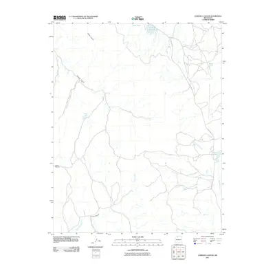
2011 Map of Cordova Canyon
USGS Topo · Published 2011About this map
Cordova Canyon and La Jara Canyon carve through this high northern New Mexico landscape in Rio Arriba County. The drainage network is defined by La Jara Creek and Boulder Creek, which feed several named upland water bodies including Luna Lake, Enbom Lake, and Lower Mundo. This modern survey documents the contemporary hydrology of the region, where catchments like Muniz Pond and Atole Pond dot the terrain alongside the winding path of Stone Lake Rd. The map illustrates the characteristic canyon-and-creek topography of the area, showing how seasonal water courses like Soldier Canyon and Burns Canyon navigate the local elevations before joining the larger creek systems that define this part of the state.
Find a feature on this map
12 named features on this map. Tap any name to fly to it.
Don’t see what you’re looking for? This feature index may not catch every label — zoom into the map to look around manually.
Map Details
Editions of this 2011 Cordova Canyon Map
This is the sole edition of this map. No revisions or reprints were ever made.
Other maps of this area

1889 · Largo
USGS Topo · 1:250,000

1895 · Largo
USGS Topo · 1:250,000

1954 · Aztec
USGS Topo · 1:250,000

1955 · Lumberton
USGS Topo · 1:62,500

1955 · Boulder Lake
USGS Topo · 1:62,500

1958 · Aztec
USGS Topo · 1:250,000

1962 · Aztec
USGS Topo · 1:250,000
1963 · Cement Lake
USGS Topo · 1:24,000
1963 · John Mills Lake
USGS Topo · 1:24,000
1963 · Wirt Canyon
USGS Topo · 1:24,000