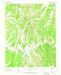
1963 Map of John Mills Lake
USGS Topo · Published 1966About this map
John Mills Lake and the surrounding high-altitude terrain of Rio Arriba County dominate this mid-century landscape, defined by deep incisions like Burns Canyon and Cordova Canyon. The map reveals a remote area managed for utility and observation, featuring a Lookout Tower BM 8159 on a high ridge and several Wells scattered across the northern sections. Transportation is limited to rugged routes such as Pounds Mill Road, which snakes through the drainage systems. Water resources are critical in this environment, represented by the concentrated blue of Dulce Lake and isolated points like Puerto Spring. The topography is marked by significant landmarks like Piedra Agujero, while a Roadside Park suggests the presence of travelers through this isolated stretch of New Mexico high country during the early 1960s.
Find a feature on this map
18 named features on this map. Tap any name to fly to it.
Don’t see what you’re looking for? This feature index may not catch every label — zoom into the map to look around manually.
Map Details
Editions of this 1963 John Mills Lake Map
This is the sole edition of this map. No revisions or reprints were ever made.
Other maps of this area

1889 · Largo
USGS Topo · 1:250,000

1895 · Largo
USGS Topo · 1:250,000

1954 · Aztec
USGS Topo · 1:250,000

1955 · Lumberton
USGS Topo · 1:62,500

1955 · Boulder Lake
USGS Topo · 1:62,500

1958 · Aztec
USGS Topo · 1:250,000

1962 · Aztec
USGS Topo · 1:250,000
1963 · Cement Lake
USGS Topo · 1:24,000
1963 · Wirt Canyon
USGS Topo · 1:24,000
1963 · Bixler Ranch
USGS Topo · 1:24,000