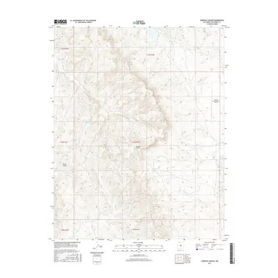
2017 Map of Cordova Canyon
USGS Topo · Published 2017About this map
The Jicarilla Apache Nation Airport anchors the northeastern plateau of this Rio Arriba County landscape, where the high desert terrain is carved by deep drainages and intermittent water sources. This 2017 survey captures a remote section of Northern New Mexico defined by the namesake Cordova Canyon and Burns Canyon, reflecting a topography where elevation changes dictate the sparse infrastructure. Pockets of water, such as Muniz Pond, Luna Lake, and Enbom Lake, provide vital landmarks in an otherwise arid environment. The map details the complex drainage systems of Boulder Cr and La Jara Cr, which shape the local geography and historical land use patterns within these tribal lands. The absence of dense residential settlement highlights the area’s primary role for transportation and resource management in the early 21st century.
Find a feature on this map
14 named features on this map. Tap any name to fly to it.
Don’t see what you’re looking for? This feature index may not catch every label — zoom into the map to look around manually.
Map Details
Editions of this 2017 Cordova Canyon Map
This is the sole edition of this map. No revisions or reprints were ever made.
Other maps of this area

1889 · Largo
USGS Topo · 1:250,000

1895 · Largo
USGS Topo · 1:250,000

1954 · Aztec
USGS Topo · 1:250,000

1955 · Lumberton
USGS Topo · 1:62,500

1955 · Boulder Lake
USGS Topo · 1:62,500

1958 · Aztec
USGS Topo · 1:250,000

1962 · Aztec
USGS Topo · 1:250,000
1963 · Cement Lake
USGS Topo · 1:24,000
1963 · John Mills Lake
USGS Topo · 1:24,000
1963 · Wirt Canyon
USGS Topo · 1:24,000