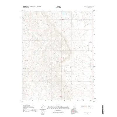
2020 Map of Cordova Canyon
USGS Topo · Published 2020About this map
Cordova Canyon and Burns Canyon define the complex drainage patterns of this high-elevation landscape in northern New Mexico. The area is characterized by a network of seasonal watercourses and remote access routes, such as J 13 and J 33, reflecting the tribal lands of the Jicarilla Apache Nation. Human presence is concentrated around essential infrastructure like the Jicarilla Apache Nation Airport and vital water sources including Muniz Pond and Tuna Lake. The terrain is marked by deep incisions from Boulder Cr and La Jara Cr, showing a landscape where geography and livestock or wildlife management likely dictated the placement of named tanks and ponds. This modern survey captures the region's character as a sparsely populated high-desert plateau managed for natural resources and aviation connectivity.
Find a feature on this map
19 named features on this map. Tap any name to fly to it.
Don’t see what you’re looking for? This feature index may not catch every label — zoom into the map to look around manually.
Map Details
Editions of this 2020 Cordova Canyon Map
This is the sole edition of this map. No revisions or reprints were ever made.
Other maps of this area

1889 · Largo
USGS Topo · 1:250,000

1895 · Largo
USGS Topo · 1:250,000

1954 · Aztec
USGS Topo · 1:250,000

1955 · Lumberton
USGS Topo · 1:62,500

1955 · Boulder Lake
USGS Topo · 1:62,500

1958 · Aztec
USGS Topo · 1:250,000

1962 · Aztec
USGS Topo · 1:250,000
1963 · Cement Lake
USGS Topo · 1:24,000
1963 · John Mills Lake
USGS Topo · 1:24,000
1963 · Wirt Canyon
USGS Topo · 1:24,000