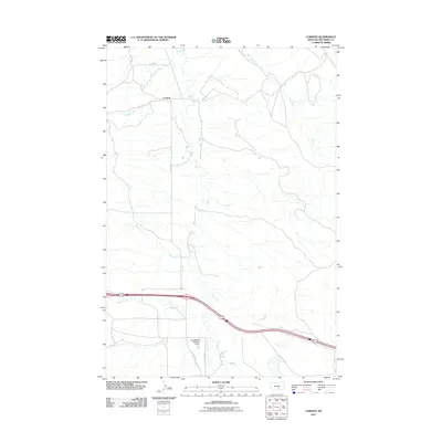
2011 Map of Corinth
USGS Topo · Published 2011About this map
Corinth sits at a crossroads of water and transport in Big Horn County, where the north-south winding of Fly Creek meets the east-west flow of Tenmile Creek. This region of Montana is defined by its drainage basins, with several tributaries such as Hay Creek and Spring Creek cutting through the landscape. The infrastructure is sparse, centered on rural access roads like Fly Creek Rd and S Fly Creek Rd, alongside more modern interventions like the Kjeldgaard Number 1 Dam. This dam represents the essential water management required in the arid plains, supporting local agriculture and land use. The map illustrates a high-plains environment where settlement is dictated by the availability of water, showing how local landmarks and water bodies like Deer Creek serve as the primary identifiers for navigation and land ownership.
Find a feature on this map
9 named features on this map. Tap any name to fly to it.
Don’t see what you’re looking for? This feature index may not catch every label — zoom into the map to look around manually.
Map Details
Editions of this 2011 Corinth Map
This is the sole edition of this map. No revisions or reprints were ever made.
Other maps of this area

1893 · Huntley
USGS Topo · 1:125,000

1894 · Fort Custer
USGS Topo · 1:125,000

1954 · Billings
USGS Topo · 1:250,000

1954 · Hardin
USGS Topo · 1:250,000

1957 · Hardin
USGS Topo · 1:250,000

1957 · Billings
USGS Topo · 1:250,000

1958 · Billings
USGS Topo · 1:250,000

1958 · Hardin
USGS Topo · 1:250,000
1967 · Wagon Box Spring
USGS Topo · 1:24,000

1967 · Nibbe
USGS Topo · 1:24,000