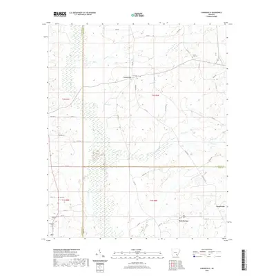
2020 Map of Cornerville
USGS Topo · Published 2020About this map
Cornerville serves as a central point in this rural landscape where the boundaries of Cleveland, Lincoln, and Drew counties converge. The terrain is defined by a dense network of slow-moving water systems, including the wetland character of Beaver Slough and the winding paths of Sevenmile Cr, Tenmile Cr, and Mill Cr. These waterways dictate the local geography, separating small settlements like Rock Springs and Plantersville.
Find a feature on this map
53 named features on this map. Tap any name to fly to it.
Don’t see what you’re looking for? This feature index may not catch every label — zoom into the map to look around manually.
Map Details
Editions of this 2020 Cornerville Map
This is the sole edition of this map. No revisions or reprints were ever made.
Other maps of this area

1935 · Feenyville
USGS Topo · 1:62,500

1953 · Greenwood
USGS Topo · 1:250,000

1953 · El Dorado
USGS Topo · 1:250,000

1956 · Greenwood
USGS Topo · 1:250,000

1957 · El Dorado
USGS Topo · 1:250,000

1958 · El Dorado
USGS Topo · 1:250,000

1960 · El Dorado
USGS Topo · 1:250,000

1966 · Monticello North
USGS Topo · 1:24,000
1970 · Calmer
USGS Topo · 1:24,000

1970 · Herbine
USGS Topo · 1:24,000