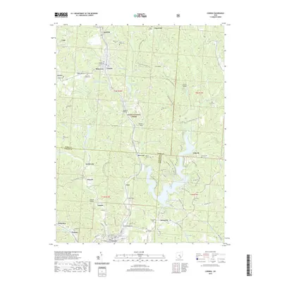
2019 Map of Corning
USGS Topo · Published 2019About this map
Glouster and Corning serve as focal points in this landscape where the borders of Perry Co, Athens Co, and Morgan Co converge. The area is defined by its deep hollows and ridges, such as Glycerin Hollow, Wildcat Hollow, and Spencer Ridge, which have long influenced local development. Significant water features like Seimer Pond and the New York Central Reservoir 9426 highlight the region's industrial and resource-based history. Genealogists will find a high density of burial sites across the terrain, including Corning Catholic Cem, Millertown Methodist Cem, and the Rendville Cem. Much of the central portion is dominated by the Wayne National Forest, preserving the winding course of Sunday Cr and its tributaries as they flow south through Palos toward Bishopville.
Find a feature on this map
99 named features on this map. Tap any name to fly to it.
Don’t see what you’re looking for? This feature index may not catch every label — zoom into the map to look around manually.
Map Details
Editions of this 2019 Corning Map
This is the sole edition of this map. No revisions or reprints were ever made.
Other maps of this area

1903 · Athens
USGS Topo · 1:62,500

1904 · Chesterhill
USGS Topo · 1:62,500

1905 · Athens
USGS Topo · 1:62,500

1906 · Chesterhill
USGS Topo · 1:62,500

1910 · Mc Connelsville
USGS Topo · 1:62,500

1911 · New Lexington
USGS Topo · 1:62,500

1947 · Columbus
USGS Topo · 1:250,000

1949 · Clarksburg
USGS Topo · 1:250,000

1956 · Clarksburg
USGS Topo · 1:250,000

1960 · Amesville
USGS Topo · 1:24,000