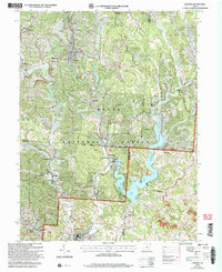
2002 Map of Corning
USGS Topo · Published 2006About this map
Wayne National Forest dominates the terrain of south-central Ohio in this 2002 revision, where the rolling hills of the Scioto River Purchase meet the deep waters of Burr Oak Reservoir. The landscape is a study in resource management and recreation, featuring the Tom Jenkins Dam and the expansive Burr Oak State Park. While much of the area has transitioned to conservation and leisure, the footprint of heavy industry remains visible through numerous Strip Mines and Gas Wells scattered across the ridges near Corning and Glouster. The map details a dense network of early settlements such as Millertown, Congo, and Hunterdon, alongside established family landmarks like Asbury Cem and Stuart Cem. Regional geography is further defined by the winding course of Sunday Creek and its many branches, including Glycerin Hollow and Wildcat Hollow.
Find a feature on this map
63 named features on this map. Tap any name to fly to it.
Don’t see what you’re looking for? This feature index may not catch every label — zoom into the map to look around manually.
Map Details
Editions of this 2002 Corning Map
This is the sole edition of this map. No revisions or reprints were ever made.
Other maps of this area

1903 · Athens
USGS Topo · 1:62,500

1904 · Chesterhill
USGS Topo · 1:62,500

1905 · Athens
USGS Topo · 1:62,500

1906 · Chesterhill
USGS Topo · 1:62,500

1910 · Mc Connelsville
USGS Topo · 1:62,500

1911 · New Lexington
USGS Topo · 1:62,500

1947 · Columbus
USGS Topo · 1:250,000

1949 · Clarksburg
USGS Topo · 1:250,000

1956 · Clarksburg
USGS Topo · 1:250,000

1960 · Amesville
USGS Topo · 1:24,000