
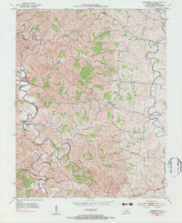
1952 Map of Cornishville
USGS Topo · Published 1953About this map
The Chaplin River carves a winding path through the heart of this Kentucky landscape, its deep meanders defining the agricultural and social layout of the region in the early 1950s. Cornishville sits at a critical bend in the river, serving as a hub for the surrounding rural communities of Duncan and Bushtown. This survey, conducted by the U.S. Geological Survey in cooperation with the Kentucky Agricultural and Industrial Development Board, captures the intricate network of country roads and farmsteads characteristic of the Bluegrass region's outer edges.
Find a feature on this map
19 named features on this map. Tap any name to fly to it.
Don’t see what you’re looking for? This feature index may not catch every label — zoom into the map to look around manually.
Map Details
Editions of this 1952 Cornishville Map
2 editions found
Other maps of this area

1905 · Harrodsburg
USGS Topo · 1:125,000

1952 · Perryville
USGS Topo · 1:24,000

1952 · Danville
USGS Topo · 1:24,000

1952 · Harrodsburg
USGS Topo · 1:24,000

1952 · Ashbrook
USGS Topo · 1:24,000

1952 · Salvisa
USGS Topo · 1:24,000

1952 · Mc Brayer
USGS Topo · 1:24,000

1953 · Mackville
USGS Topo · 1:24,000

1953 · Cardwell
USGS Topo · 1:24,000

1957 · Winchester
USGS Topo · 1:250,000