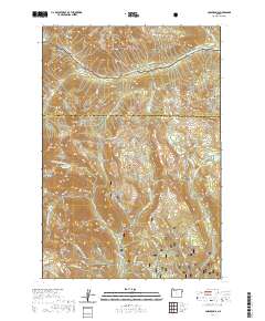
2020 Map of Cornucopia
USGS Topo · Published 2020About this map
Cornucopia sits at the base of the high peaks within the Whitman National Forest, representing a legacy of mountain settlement and resource management in the Wallowa Mountains. The landscape is defined by its complex drainage systems, where the S Fork Imnaha River and S Fork Imnaha carve through the northern terrain of the Wallowa National Forest. This 2020 survey illustrates a modern alpine environment where hydrology is heavily managed for the surrounding area, evidenced by a series of high-elevation impoundments including Red Mountain Reservoir, East Lakes Reservoir, and Steele Reservoir. These features, along with the Norway Basin and the prominence of Cornucopia Peak, highlight the intersection of natural topography and deliberate water storage. The map also traces specialized seasonal routes like the Snowmobile trail, while the southern reaches descend toward Schneider Meadows and the winding course of Pine Cr.
Find a feature on this map
64 named features on this map. Tap any name to fly to it.
Don’t see what you’re looking for? This feature index may not catch every label — zoom into the map to look around manually.
Map Details
Editions of this 2020 Cornucopia Map
This is the sole edition of this map. No revisions or reprints were ever made.
Other maps of this area

1915 · Pine
USGS Topo · 1:125,000

1954 · Cornucopia
USGS Topo · 1:62,500

1954 · Eagle Cap
USGS Topo · 1:62,500

1955 · Baker
USGS Topo · 1:250,000

1955 · Grangeville
USGS Topo · 1:250,000

1957 · Halfway
USGS Topo · 1:62,500

1957 · Sparta
USGS Topo · 1:62,500

1959 · Baker
USGS Topo · 1:250,000

1959 · Grangeville
USGS Topo · 1:250,000

1981 · Baker
USGS Topo · 1:100,000