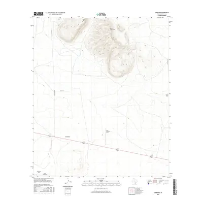
2016 Map of Cornudas
USGS Topo · Published 2016About this map
Sierra Tinaja Pinta dominates the northern landscape of this West Texas region, where the rugged peaks meet the open desert floor near the small settlement of Cornudas. This 2016 survey documents a terrain defined by ancient drainage patterns and ranching infrastructure, such as Mayfield Ranch Rd and Foster Ranch Rd, which navigate the wide basins between Miller Mtn and the various local draws. The presence of the Flying Eagle Ranch Airport adjacent to the highway corridor highlights the continued importance of private aviation in managing these expansive arid lands. For the researcher, the map captures the hydrologic network of Hitson Draw, University Draw, and Buena Vista Draw, tracing how water moves through the basin during rare precipitation events in this corner of Hudspeth County.
Find a feature on this map
11 named features on this map. Tap any name to fly to it.
Don’t see what you’re looking for? This feature index may not catch every label — zoom into the map to look around manually.
Map Details
Editions of this 2016 Cornudas Map
This is the sole edition of this map. No revisions or reprints were ever made.
Other maps of this area

1903 · Cerro Alto
USGS Topo · 1:125,000

1943 · Tepee Butte
USGS Topo · 1:62,500

1943 · San Antonio Mtn
USGS Topo · 1:62,500

1951 · Red Hills
USGS Topo · 1:62,500

1954 · Van Horn
USGS Topo · 1:250,000

1955 · Cerro Diablo
USGS Topo · 1:62,500

1958 · Van Horn
USGS Topo · 1:250,000
1978 · Molesworth Mesa South
USGS Topo · 1:24,000
1979 · Molesworth Mesa North
USGS Topo · 1:24,000
1984 · Mickey Draw West
USGS Topo · 1:24,000