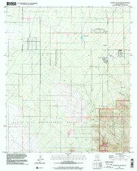
1996 Map of Corona De Tucson
USGS Topo · Published 2002About this map
Corona de Tucson sits at the northern edge of this desert landscape, where suburban expansion meets the expansive research lands of the Santa Rita Experimental Range. The map reveals a transition from the structured residential grid and its associated Golf Course to the high-desert terrain of the Coronado National Forest in the southeast. This area is characterized by a mix of utility and industry, including a major Pipeline and local extraction sites such as the Jones Quarry and the Bluestar Mine.
Find a feature on this map
22 named features on this map. Tap any name to fly to it.
Don’t see what you’re looking for? This feature index may not catch every label — zoom into the map to look around manually.
Map Details
Editions of this 1996 Corona De Tucson Map
This is the sole edition of this map. No revisions or reprints were ever made.
Other maps of this area

1904 · Patagonia
USGS Topo · 1:125,000

1904 · Tucson
USGS Topo · 1:125,000

1905 · Patagonia
USGS Topo · 1:125,000

1905 · Tucson
USGS Topo · 1:125,000

1926 · Helvetia
USGS Topo · 1:62,500

1948 · Tucson
USGS Topo · 1:62,500

1956 · Nogales
USGS Topo · 1:250,000

1956 · Tucson
USGS Topo · 1:250,000

1957 · Tucson
USGS Topo · 1:62,500

1957 · Rincon Valley
USGS Topo · 1:62,500