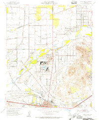
1954 Map of Corona North
USGS Topo · Published 1955About this map
Lake Norconian and the adjacent Naval Reservation anchor the central portion of this mid-century landscape, which captures a transition from large agricultural estates to established suburban communities. The Naval Hospital site stands out as a significant institutional presence near Norco, while to the north, the terrain is defined by the Santa Ana River and the dry beds of Cucamonga Creek. The area shows a structured grid of poultry and citrus production, with local infrastructure including the East Vale School and the Fuller Ranch. To the south, the city of Corona is depicted with its distinctive circular layout and the Atchison Topeka and Santa Fe Railroad corridor. The map records the early development of Home Gardens and Mira Loma, set against the backdrop of the Jurupa and La Sierra hills, shortly after the construction of the Prado Flood Control Basin.
Find a feature on this map
45 named features on this map. Tap any name to fly to it.
Don’t see what you’re looking for? This feature index may not catch every label — zoom into the map to look around manually.
Map Details
Editions of this 1954 Corona North Map
2 editions found
Other maps of this area

1896 · San Bernardino
USGS Topo · 1:62,500

1897 · Cucamonga
USGS Topo · 1:62,500

1898 · San Bernardino
USGS Topo · 1:62,500

1900 · Cucamonga
USGS Topo · 1:62,500

1901 · Southern California Sheet No. 1
USGS Topo · 1:250,000

1901 · San Bernardino
USGS Topo · 1:62,500

1901 · Elsinore
USGS Topo · 1:125,000

1901 · Riverside
USGS Topo · 1:62,500

1902 · Corona
USGS Topo · 1:125,000

1903 · Cucamonga
USGS Topo · 1:62,500