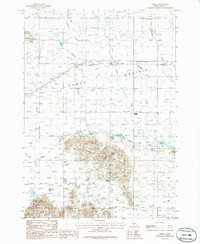
1986 Map of Corral
USGS Topo · Published 1986About this map
Camas Prairie dominates the landscape in this mid-1980s Idaho survey, where the settlement of Corral and the aptly named Punkin Corner anchor a region of high-desert ranching and farming. The topography is defined by the broad flatlands of the prairie giving way to prominent features like Johnson Hill and Big Bluff near the southern margin. A network of small watercourses, including Camas Creek, Dairy Creek, and Threemile Creek, drains the basin, while family-named water sources such as Brownell Spring and Leahy Spring hint at early settlement and water rights essential to the local economy.
Find a feature on this map
28 named features on this map. Tap any name to fly to it.
Don’t see what you’re looking for? This feature index may not catch every label — zoom into the map to look around manually.
Map Details
Editions of this 1986 Corral Map
This is the sole edition of this map. No revisions or reprints were ever made.
Other maps of this area

1892 · Camas Prairie
USGS Topo · 1:125,000

1893 · Camas Prairie
USGS Topo · 1:125,000

1955 · Hailey
USGS Topo · 1:250,000

1957 · Fairfield
USGS Topo · 1:62,500

1957 · Davis Mountain
USGS Topo · 1:62,500

1958 · King Hill
USGS Topo · 1:62,500

1959 · Hailey
USGS Topo · 1:250,000

1962 · Hailey
USGS Topo · 1:250,000

1963 · Deer Mountain
USGS Topo · 1:24,000

1963 · Hill City
USGS Topo · 1:24,000