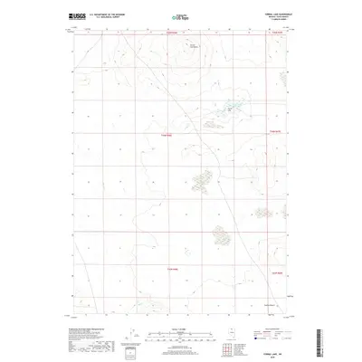
2018 Map of Corral Lake
USGS Topo · Published 2018About this map
Corral Lake and its accompanying Corral Lake Reservoir serve as central landmarks in this high-desert region of Elko County. The landscape is defined by the elevation of Corral Lake Butte to the north and the expansive Owyhee Desert that stretches across the southern reaches of the map. This terrain is characterized by seasonal water systems, including the drainage of Wolf Cr, which illustrates the importance of water management and natural catchments in this part of Nevada. Sparse and specialized, the map highlights the geographic isolation of the area, punctuated primarily by these few named water and terrain features. It captures a specific intersection of natural topography and remote land use within the township and range system, providing a clear record of the region’s physical geography in the early 21st century.
Find a feature on this map
11 named features on this map. Tap any name to fly to it.
Don’t see what you’re looking for? This feature index may not catch every label — zoom into the map to look around manually.
Map Details
Editions of this 2018 Corral Lake Map
This is the sole edition of this map. No revisions or reprints were ever made.
Other maps of this area

1955 · McDermitt
USGS Topo · 1:250,000

1959 · McDermitt
USGS Topo · 1:250,000

1973 · McCleary Wells
USGS Topo · 1:24,000

1973 · Star Valley Ridge SW
USGS Topo · 1:24,000

1973 · Button Lake Well
USGS Topo · 1:24,000

1973 · Corral Lake
USGS Topo · 1:24,000

1973 · Twelvemile Flat
USGS Topo · 1:24,000
1973 · Star Valley Ridge SE
USGS Topo · 1:24,000

1973 · Humboldt Hill
USGS Topo · 1:24,000

1974 · Winters Ranch Reservoir
USGS Topo · 1:24,000