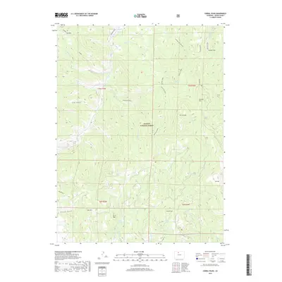
2019 Map of Corral Peaks
USGS Topo · Published 2019About this map
Arapaho National Forest dominates this section of Grand County, where high-elevation drainage systems like E Fork Troublesome Cr and Wheatley Cr carve through complex mountain terrain. The map captures a landscape defined by prominent summits, including Corral Peaks, Searight Mtn, and Slide Mtn, which overlook a network of gulches and parks. Of particular interest to local water history is the presence of Musgrave Ditch and the Scholl Reservoir, highlighting the engineering required to manage water resources in this part of the Rockies. To the north and south, large open areas such as Hay Park and Buffalo Park provide clearings amidst the timbered slopes. The road network is limited to a few specific corridors, most notably Co RD 21 and Co HWY 216, which skirt the lower elevations near Black Mtn and Grouse Mtn.
Find a feature on this map
34 named features on this map. Tap any name to fly to it.
Don’t see what you’re looking for? This feature index may not catch every label — zoom into the map to look around manually.
Map Details
Editions of this 2019 Corral Peaks Map
This is the sole edition of this map. No revisions or reprints were ever made.
Other maps of this area

1954 · Craig
USGS Topo · 1:250,000

1956 · Radial Mountain
USGS Topo · 1:24,000

1956 · Kremmling
USGS Topo · 1:62,500

1956 · Parkview Mountain
USGS Topo · 1:24,000

1956 · Hyannis Peak
USGS Topo · 1:24,000

1956 · Hyannis Peak
USGS Topo · 1:62,500

1956 · Rand
USGS Topo · 1:62,500

1957 · Craig
USGS Topo · 1:250,000

1957 · Hot Sulphur Springs
USGS Topo · 1:62,500

1958 · Craig
USGS Topo · 1:250,000