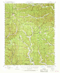
1944 Map of Corridon
USGS Topo · Published 1968About this map
Bunker and Reynolds anchor this mid-century portrait of the Ozark highlands, where small-scale farming and timber harvesting shaped the landscape of the Clark National Forest. The map reveals a dense network of upland hollows and valley bottomlands, such as Dickens Valley and Fruit Valley, each housing independent rural institutions. Many of these family-named landmarks, like Davis Cem and Chitwood Cem, provide vital clues for genealogists tracing ancestral homesteads.
Find a feature on this map
62 named features on this map. Tap any name to fly to it.
Don’t see what you’re looking for? This feature index may not catch every label — zoom into the map to look around manually.
Map Details
Editions of this 1944 Corridon Map
2 editions found
Other maps of this area

1915 · Eminence
USGS Topo · 1:62,500

1917 · Eminence
USGS Topo · 1:62,500

1924 · Edgehill
USGS Topo · 1:62,500

1926 · Edgehill
USGS Topo · 1:62,500

1928 · Cardareva
USGS Topo · 1:62,500

1941 · Stone Hill
USGS Topo · 1:62,500

1943 · Ellington
USGS Topo · 1:62,500

1943 · Lesterville
USGS Topo · 1:62,500

1943 · Boss
USGS Topo · 1:62,500

1944 · Corridon
USGS Topo · 1:62,500