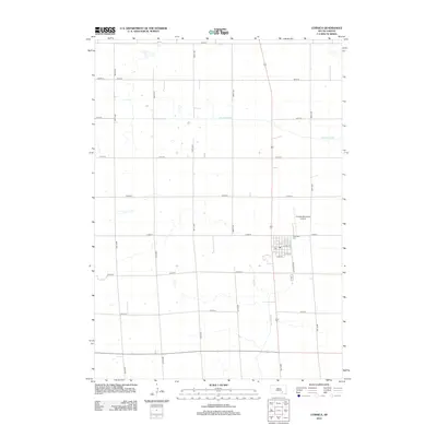
2012 Map of Corsica
USGS Topo · Published 2012About this map
Corsica serves as the primary hub of this Douglas County landscape, where the town's grid is organized around landmarks such as the Po and E Main St. The surrounding countryside is defined by the section-line road network, a signature of Great Plains surveying, which connects local farmsteads to the settlement. Water drainage patterns are marked by the meandering paths of Choteau Creek in the north and Andes Creek further south, both carving gentle paths through the agricultural terrain. Aviation infrastructure is represented by the Corsica Municipal Airport situated just north of the town center, while the local heritage is anchored at Graceland Cem along the eastern edge of the community. This 2012 survey captures the enduring layout of a South Dakota farming community, maintaining its traditional town structure while integrated into modern transportation corridors.
Find a feature on this map
25 named features on this map. Tap any name to fly to it.
Don’t see what you’re looking for? This feature index may not catch every label — zoom into the map to look around manually.
Map Details
Editions of this 2012 Corsica Map
This is the sole edition of this map. No revisions or reprints were ever made.
Other maps of this area

1899 · Mitchell
USGS Topo · 1:125,000

1955 · Mitchell
USGS Topo · 1:250,000

1959 · Mitchell
USGS Topo · 1:250,000

1979 · Geddes SE
USGS Topo · 1:24,000

1979 · New Holland
USGS Topo · 1:24,000
1979 · Armour
USGS Topo · 1:24,000

1979 · Aurora Center
USGS Topo · 1:24,000
1979 · Armour SW
USGS Topo · 1:24,000

1980 · Stickney
USGS Topo · 1:24,000

1980 · Corsica Lake
USGS Topo · 1:24,000