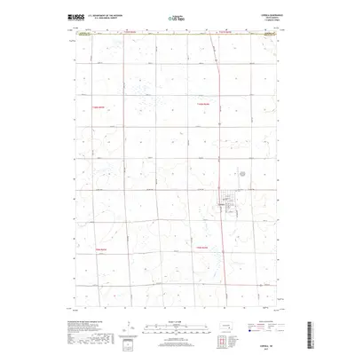
2017 Map of Corsica
USGS Topo · Published 2017About this map
Corsica serves as the primary hub of this eastern Douglas County landscape, situated amidst an extensive grid of section-line roads and agricultural tracts. The town’s orderly street plan is anchored by E Main St and S Dakota Ave, while its connectivity to the wider region is maintained by the Corsica Municipal Airport to the northeast. Local history and genealogy interests are centered at Graceland Cem, which sits just east of the main settlement along Co HWY 560.
Find a feature on this map
35 named features on this map. Tap any name to fly to it.
Don’t see what you’re looking for? This feature index may not catch every label — zoom into the map to look around manually.
Map Details
Editions of this 2017 Corsica Map
This is the sole edition of this map. No revisions or reprints were ever made.
Other maps of this area

1899 · Mitchell
USGS Topo · 1:125,000

1955 · Mitchell
USGS Topo · 1:250,000

1959 · Mitchell
USGS Topo · 1:250,000

1979 · Geddes SE
USGS Topo · 1:24,000

1979 · New Holland
USGS Topo · 1:24,000
1979 · Armour
USGS Topo · 1:24,000

1979 · Aurora Center
USGS Topo · 1:24,000
1979 · Armour SW
USGS Topo · 1:24,000

1980 · Stickney
USGS Topo · 1:24,000

1980 · Corsica Lake
USGS Topo · 1:24,000