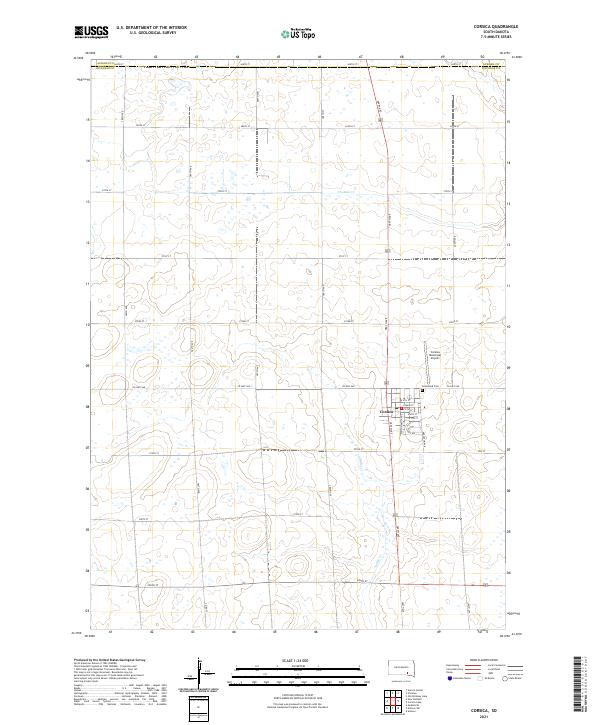
2021 Map of Corsica
USGS Topo · Published 2021About this map
Corsica serves as the central hub for this portion of Douglas County, showing a well-defined grid of local streets including South Dakota Ave and E Main St. The landscape is largely defined by the agricultural section lines of the Public Land Survey System, with the terrain drained by the winding course of Choteau Cr. Historical and genealogical interest is found at Graceland Cem, situated just east of the main town site along Co Hwy 560. The map also details the Corsica Municipal Airport to the northeast, reflecting the importance of regional aviation in this rural South Dakota setting. Roads like Co Rd 17 and a network of numbered section-line roads, such as 389th Ave, illustrate the transition between the urban settlement and the surrounding plains.
Find a feature on this map
37 named features on this map. Tap any name to fly to it.
Don’t see what you’re looking for? This feature index may not catch every label — zoom into the map to look around manually.
Map Details
Editions of this 2021 Corsica Map
This is the sole edition of this map. No revisions or reprints were ever made.
Other maps of this area

1899 · Mitchell
USGS Topo · 1:125,000

1955 · Mitchell
USGS Topo · 1:250,000

1959 · Mitchell
USGS Topo · 1:250,000

1979 · Geddes SE
USGS Topo · 1:24,000

1979 · New Holland
USGS Topo · 1:24,000
1979 · Armour
USGS Topo · 1:24,000

1979 · Aurora Center
USGS Topo · 1:24,000
1979 · Armour SW
USGS Topo · 1:24,000

1980 · Stickney
USGS Topo · 1:24,000

1980 · Corsica Lake
USGS Topo · 1:24,000