
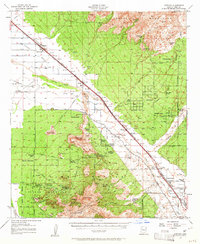
1957 Map of Cortaro
USGS Topo · Published 1959About this map
The Santa Cruz River valley north of Tucson defines this landscape, where the Southern Pacific railroad and Casa Grande Highway facilitate the growth of agricultural and ranching hubs like Marana and Rillito. The valley floor is heavily influenced by the presence of Cortaro Farms and the Cortaro Ditch, illustrating the intensive irrigation required to sustain cultivation in this arid environment. To the east, the Tortolita Mountains rise above the basin, while the southern portion of the sheet is dominated by the jagged peaks of the Tucson Mountains, including Wasson Peak and Safford Peak.
Find a feature on this map
76 named features on this map. Tap any name to fly to it.
Don’t see what you’re looking for? This feature index may not catch every label — zoom into the map to look around manually.
Map Details
Editions of this 1957 Cortaro Map
2 editions found
Other maps of this area

1904 · Tucson
USGS Topo · 1:125,000

1905 · Tucson
USGS Topo · 1:125,000

1911 · Winkelman
USGS Topo · 1:125,000

1913 · Winkelman
USGS Topo · 1:125,000

1925 · San Xavier
USGS Topo · 1:62,500

1934 · Tucson Mountains
USGS Topo · 1:125,000

1934 · Newman Peak
USGS Topo · 1:125,000

1941 · Cocoraque Butte
USGS Topo · 1:62,500

1943 · Cocoraque Butte
USGS Topo · 1:62,500

1943 · San Xavier Mission
USGS Topo · 1:62,500