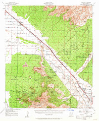
1957 Map of Cortaro
USGS Topo · Published 1961About this map
Santa Cruz River bottomlands and the foothills of the Tortolita Mountains define this Pima County landscape during a mid-century period of ranching and early development. The Southern Pacific rail line and the Casa Grande Highway serve as the primary artery for local trade, connecting settlements like Marana, Rillito, and Cortaro. Agriculture is anchored by the Cortaro Farms Ditch, while the surrounding desert terrain is dotted with active and legacy mining operations, including the Gila Monster Mine, Mile-wide Mine, and Yuma Mine.
Find a feature on this map
102 named features on this map. Tap any name to fly to it.
Don’t see what you’re looking for? This feature index may not catch every label — zoom into the map to look around manually.
Map Details
Editions of this 1957 Cortaro Map
2 editions found

Other maps of this area

1904 · Tucson
USGS Topo · 1:125,000

1905 · Tucson
USGS Topo · 1:125,000

1911 · Winkelman
USGS Topo · 1:125,000

1913 · Winkelman
USGS Topo · 1:125,000

1925 · San Xavier
USGS Topo · 1:62,500

1934 · Tucson Mountains
USGS Topo · 1:125,000

1934 · Newman Peak
USGS Topo · 1:125,000

1941 · Cocoraque Butte
USGS Topo · 1:62,500

1943 · Cocoraque Butte
USGS Topo · 1:62,500

1943 · San Xavier Mission
USGS Topo · 1:62,500