
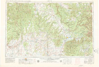
1956 Map of Cortez
USGS Topo · Published 1972About this map
Cortez serves as a central hub for this Four Corners landscape during the mid-20th century, where the high plateaus of Colorado meet the canyonlands of Utah. The geography is defined by significant indigenous lands, including the Navajo Indian Reservation and the Ute Mountain Indian Reservation centered at Towaoc. Cultural preservation is evident at Mesa Verde National Park and Hovenweep National Monument, while higher elevations are managed within the San Juan National Forest and Manti-La Sal National Forest.
Find a feature on this map
78 named features on this map. Tap any name to fly to it.
Don’t see what you’re looking for? This feature index may not catch every label — zoom into the map to look around manually.
Map Details
Editions of this 1956 Cortez Map
2 editions found
Other maps of this area

1883 · Marsh Pass
USGS Topo · 1:250,000

1885 · San Rafael
USGS Topo · 1:250,000

1885 · La Sal
USGS Topo · 1:250,000

1886 · Henry Mountains
USGS Topo · 1:250,000

1886 · Abajo
USGS Topo · 1:250,000

1889 · Largo
USGS Topo · 1:250,000

1889 · Chaco
USGS Topo · 1:250,000

1892 · Marsh Pass
USGS Topo · 1:250,000

1892 · Abajo
USGS Topo · 1:250,000

1892 · Henry Mountains
USGS Topo · 1:250,000