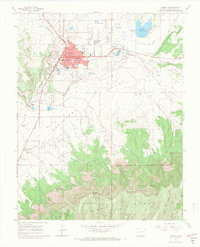
1965 Map of Cortez
USGS Topo · Published 1967About this map
Indian Ruins and Cliff Dwellings dot the landscape of the Mesa Verde National Park and the North Rim, illustrating the archaeological richness of the Four Corners region in the mid-1960s. The town of Cortez serves as the regional hub, characterized by a grid of streets like Montezuma Ave and Main St, and anchored by institutions such as Calkins Jr High Sch and Kemper Sch. To the south, the Ute Mountain Indian Reservation borders the deep cuts of Navajo Canyon, while the agricultural importance of water management is evident in the network of ditches and the Totten Reservoir. This survey captures the intersection of ancient history and modern settlement at a time when the County Airport and local landmarks like the Radio Towers (KVFC) were prominent fixtures of the growing community.
Find a feature on this map
51 named features on this map. Tap any name to fly to it.
Don’t see what you’re looking for? This feature index may not catch every label — zoom into the map to look around manually.
Map Details
Editions of this 1965 Cortez Map
3 editions found
Other maps of this area

1912 · Soda Canyon
USGS Topo · 1:62,500

1915 · Soda Canyon
USGS Topo · 1:62,500

1956 · Cortez
USGS Topo · 1:250,000

1958 · Cortez SW
USGS Topo · 1:24,000

1958 · Cortez
USGS Topo · 1:250,000

1959 · Cortez
USGS Topo · 1:250,000

1962 · Cortez
USGS Topo · 1:250,000

1965 · Cortez
USGS Topo · 1:24,000

1965 · Dolores East
USGS Topo · 1:24,000

1965 · Dolores West
USGS Topo · 1:24,000