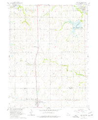
1964 Map of Cortland
USGS Topo · Published 1977About this map
Union Pacific rail lines anchor the landscape of this 1960s rural survey, connecting the villages of Cortland, Princeton, and Hickman. The terrain is defined by the winding Middle Branch Big Nemaha River and its various tributaries, which separate the larger townships of Buda, South Pass, and Nemaha. This area, situated along the Lancaster and Gage County line, highlights a mid-century agricultural corridor where local infrastructure was heavily focused on school districts and small community burial grounds.
Find a feature on this map
28 named features on this map. Tap any name to fly to it.
Don’t see what you’re looking for? This feature index may not catch every label — zoom into the map to look around manually.
Map Details
Editions of this 1964 Cortland Map
2 editions found
Other maps of this area

1897 · Lincoln
USGS Topo · 1:125,000

1955 · Lincoln
USGS Topo · 1:250,000

1957 · Lincoln
USGS Topo · 1:250,000

1957 · Clatonia
USGS Topo · 1:24,000

1958 · Lincoln
USGS Topo · 1:250,000

1964 · Cortland
USGS Topo · 1:24,000

1964 · Pickrell
USGS Topo · 1:24,000
1964 · Hallam
USGS Topo · 1:24,000

1964 · Denton
USGS Topo · 1:24,000

1964 · Roca
USGS Topo · 1:24,000