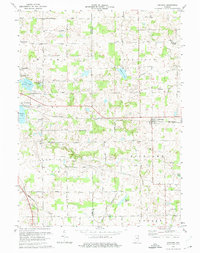
1973 Map of Corunna
USGS Topo · Published 1974About this map
The Penn Central rail line cuts a straight horizontal path across the landscape, anchoring the village of Corunna and connecting it to nearby Kendallville. This 1970s survey captures a rural landscape defined by township boundaries like Fairfield and Richland, where small social hubs such as Fairfield Center and Wayne Center served as central points for local agricultural life. A network of country churches and schools, including Allen Chapel, Zion Church, and the Township School, reflects the decentralized community structure of the time.
Find a feature on this map
34 named features on this map. Tap any name to fly to it.
Don’t see what you’re looking for? This feature index may not catch every label — zoom into the map to look around manually.
Map Details
Editions of this 1973 Corunna Map
This is the sole edition of this map. No revisions or reprints were ever made.
Other maps of this area

1942 · Ashley
USGS Topo · 1:24,000

1942 · Stroh
USGS Topo · 1:24,000

1947 · Wolcottville
USGS Topo · 1:24,000

1953 · Fort Wayne
USGS Topo · 1:250,000

1955 · Corunna
USGS Topo · 1:24,000

1955 · Ege
USGS Topo · 1:24,000

1955 · Kendallville
USGS Topo · 1:24,000

1956 · Fort Wayne
USGS Topo · 1:250,000

1957 · Auburn
USGS Topo · 1:24,000

1957 · Waterloo
USGS Topo · 1:24,000