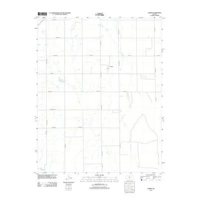
2012 Map of Corwin
USGS Topo · Published 2012About this map
Corwin sits at the heart of this agricultural landscape in Harper County, where the plains are defined by a network of drainage systems and long-established section roads. The terrain is dominated by the wandering paths of Salty Cr and Little Sandy Cr, which carve shallow routes through the prairie before reaching the Medicine Lodge River at the southern boundary. Small bodies of water like Spicer Lake and Hargis Lake punctuate the grid, providing localized landmarks in an area focused on ranching and cultivation. The map preserves local road names that suggest the region's history and geography, such as the Rattlesnake Trl, Black Kettle, and Driftwood. This 2012 survey illustrates the enduring rural structure of the Kansas borderlands, reflecting a settlement pattern that has remained largely unchanged for generations.
Find a feature on this map
23 named features on this map. Tap any name to fly to it.
Don’t see what you’re looking for? This feature index may not catch every label — zoom into the map to look around manually.
Map Details
Editions of this 2012 Corwin Map
This is the sole edition of this map. No revisions or reprints were ever made.
Other maps of this area

1889 · Anthony
USGS Topo · 1:125,000

1891 · Anthony
USGS Topo · 1:125,000

1955 · Woodward
USGS Topo · 1:250,000

1955 · Pratt
USGS Topo · 1:250,000

1958 · Woodward
USGS Topo · 1:250,000

1959 · Pratt
USGS Topo · 1:250,000

1969 · Amorita
USGS Topo · 1:24,000

1969 · Burlington
USGS Topo · 1:24,000
1969 · Manchester NW
USGS Topo · 1:24,000

1972 · Attica
USGS Topo · 1:24,000